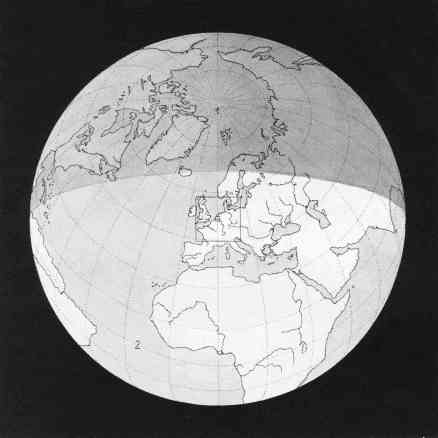
| 8. |
Until now we have been getting each time a wider view of our "world." We
now see the whole of it as a limited dwelling place in the surrounding blackness
of space. Whereas in the last picture we could see countries, we now can see
five of the six continents: only Australia does not come into the picture. We notice
that the northern part of the globe is in shadow; as the picture was taken on
December 21st at noon, the sun was in the south, and daylight did not reach
farther north than the Arctic Circle. This shaded part of the earth in reality
would have been much darker. It has, however, been left a dark grey, in order
to show the visible portions of North America and northeast Asia. The North
Pole (1) and the equator (2), as well as the meridians and the parallels of latitude
for every 15 degrees, are shown as dotted lines.
|
1 cm. in picture = 108 cm. = 1,000 km. | Scale = 1:100,000,000 = 1:108 |
|